
If you could stand in Spilsby’s Market Place eight hundred years ago, you might have been standing in the wrong Spilsby.
Because Spilsby hasn’t always sat where it does today. A whole earlier settlement — now known as Old Spilsby — lies down in the valley near Partney Bridge. It isn’t a romantic legend, either. It is a nationally protected Scheduled Monument, with its shape still written into the ground as ridges, banks, ditches, and the faint sunken lines of old roads.
The Spilsby that disappeared
Old Spilsby sits in the shallow valley of a tributary of the River Lymn, about 1 kilometre north‑east of the modern town. It is the remains of a small medieval community: house plots, yards, enclosures, and hollow ways (sunken lanes) that once carried people and animals through the settlement.
What makes it so striking is that the landscape around it still carries the imprint of how people worked the land. You can still trace complete blocks of ridge‑and‑furrow cultivation — the long, corrugated pattern left by medieval ploughing — arranged in furlongs and bounded by tracks and ditches. In other words: this isn’t just “where houses were”, but a surviving snapshot of how a whole farming community functioned.
The official record suggests Old Spilsby existed before the late 11th century, and that it was depopulated after the present market town was established in the mid‑13th century. By the late 18th century it was completely deserted.
Was it even called “Spilsby”?
For the medieval period, we can be fairly confident we are looking at “Spilsby”, because the settlement is referenced in the Domesday Book as Spilesbi.
Before that, things get foggier. Place‑names evolve, spellings shift, and earlier records can be patchy. So the honest answer is: we know the name in the 11th century, but we can’t be certain what local people might have called the place before written records pinned it down.
A valley with a heavyweight neighbour
If you’ve heard Partney mentioned in the same breath as Old Spilsby, that’s not accidental.
Partney sat in the same valley corridor and had real ecclesiastical weight. Early medieval writers refer to a monastery there (the place-name appears in Bede as Peartaneu), which hints at Partney being a spiritual and administrative anchor long before Spilsby became the dominant market centre.
So, for a long stretch of time, the valley wasn’t just empty fields — it was a busy landscape of settlement, routes, and religious importance.
So why did Spilsby move?
There is no single surviving document that bluntly says, “We are moving the town because the valley is too wet.” Medieval history almost never gives you that neat a quote.
What we do have is a strong pattern made up of three types of evidence:
First, the shape of the land and the siting of settlements. Valley bottoms can be productive and well‑watered, but they also come with damp ground and the risk of flooding. Higher ground is drier, breezier, and easier to keep passable in winter.
Second, the logic of a market town. A market needs space, visibility, and access. Spilsby’s modern centre sits on higher ground with a market place and radiating streets — exactly the kind of layout you would expect when trade becomes the organising principle of the town.
Third, the paper trail of market rights. Academic catalogues of medieval market charters record a grant in 1255 associated with John Beck (or de Beke) at Spilsby. Later records show a royal grant to Robert de Willoughby in April 1305.
Those two dates (and a third one you sometimes see — 1302) are the source of a lot of local confusion. The simplest way to make sense of it is this: the shift to a hilltop market centre looks like a process, not a single overnight relocation. The market’s legal paperwork gets recorded at specific points, while the physical move and the abandonment of Old Spilsby plays out over decades.
The town we see today was built to be seen
Even if you’ve never heard of Old Spilsby, you’ve walked through the evidence of what replaced it.
A medieval market town isn’t just “a village that got bigger”. It’s a re‑orientation of local life around trade, rents, movement, and status. Spilsby’s Market Place becomes the stage set for that shift.
And then there are the landmark clues.
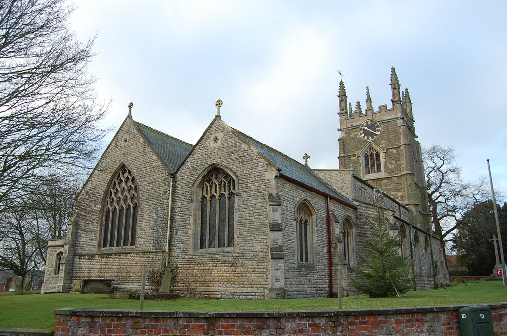
St James’ Church originates from the 14th century and is noticeably large for a small market town — exactly what you would expect if Spilsby’s prosperity and local importance were rising at that moment. The Buttercross in the Market Place (a listed medieval market cross) is another reminder that the market wasn’t a side feature; it was the point.
Why Old Spilsby is protected
Historic England’s listing doesn’t protect Old Spilsby because it is picturesque. It protects it because it is unusually informative.
The site is described as one of the best surviving medieval settlement sites in the region. It is rare for having been completely deserted relatively early, and for having remained largely unaltered by later activity. It is also exceptional locally because it is directly associated with an extensive system of ridge‑and‑furrow cultivation, with complete furlongs surviving in good condition.
That combination — settlement remains plus intact farming remains — means archaeologists can read not just where people lived, but how the settlement worked socially and economically as part of the wider landscape.
Seeing it today (without damaging it)
Old Spilsby is a protected archaeological site on farmland, not an open‑air museum. The best way to appreciate it is respectfully: stick to public rights of way, don’t climb earthworks, and remember that what looks like “just a lumpy field” can be centuries of history preserved precisely because it hasn’t been disturbed.
If you ever find yourself thinking “Spilsby has always been here”, Old Spilsby is the gentle rebuttal. The town has moved before. The landscape remembers.
Location
The map below shows the exact location as specified by Historic England. The map on the Historic England listing page shows a better, more detailed map, highlighting the area Old Spilsby is believed to have covered.
References
| Source | Link |
|---|---|
| Historic England (NHLE) – Old Spilsby Scheduled Monument (List Entry 1014704) | View entry |
| Heritage Gateway (Lincolnshire HER) – Old Spilsby Deserted Medieval Village (MLI43163) | View record |
| Heritage Gateway (Lincolnshire HER) – Field System associated with Old Spilsby DMV (MLI43204) | View record |
| Open Domesday – Spilsby (Domesday Book entry) | View entry |
| Gazetteer of Markets and Fairs to 1516 (IHR) – Lincolnshire listings (Spilsby entry within page) | View Lincolnshire page |
| Calendar of Charter Rolls (Archive.org scan) – useful for searching “Spillesby” / “Bek” | View scan |
| Historic England (NHLE) – Church of St James, Spilsby (List Entry 1308892) | View entry |
| Historic England (NHLE) – Buttercross, Market Place, Spilsby (List Entry 1359735) | View entry |
| Heritage Gateway (Historic England Research Records) – Partney monastery tradition (Monument 355346) | View record |
| East Lindsey District Council – Spilsby Conservation Area Appraisal (PDF) | Open PDF |